A year in maps: six routes I’ll never forget
The best routes stay with you long after the run is over. At Footpath, we love seeing how athletes use the map to discover new places, prepare for big efforts, and turn a squiggly line into memories with friends and teammates.
This year, professional trail runner Mercedes Siegle-Gaither traveled the world chasing climbs, ridgelines, and the kind of trails you dream about. Footpath helped her plan, preview, and save the routes that defined those experiences. She was kind enough to share six of these standout routes, plus her secret spots and favorite cafes, with all of us.
Take it away, Mercedes! ☕️🏔️💭
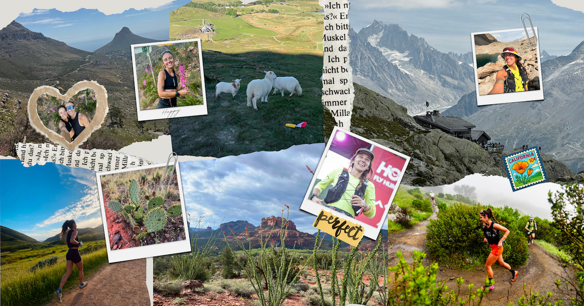
I’m Mercedes Siegle-Gaither, Wisconsinite living primarily in Colorado, a professional trail runner for Merrell, and Forestry Project Coordinator for the National Forest Foundation. I’ve had the amazing opportunity over the last two years to travel the world for trail racing, skyrunning, and just living a dream. I love spending my time in the mountains running, power hiking, skate skiing, skinning, napping, snacking. I have endless gratitude for soaking up the sun and making the most of this little life I have. All while making new friends, finding new trails to explore, and hammering cappuccinos with breve along the way. Footpath has been my go-to adventure tool abroad and at home for routing new runs, scouting race routes, and sharing runs with friends.
🌺 Honolulu, Hawaii, USA

Oahu is a great place for a hard as hell 100-miler with some of your favorite people! I decided to tackle the HURT-100 in January of 2025. Five 20-mile loops with about 5,000’ of climbing on a technical, rooty trail is what this race consists of. Try a loop for yourself and see how you feel about adding on four more. The race starts at the Hawaii Nature Center, with the second aid station at the Honolulu Botanical Gardens. Add some sightseeing on your gnarly, weekend-long run. If you’re lucky, it won’t be a sloppy mudslide, but either way, it’s a blast! If you make it through this loop, you’re only a 10-minute drive from Waikiki beach for a little dip and some sunshine. Lucky for you, this loop is primarily under canopy cover, granted that won’t save you from the humidity. So bring an ice bandana to stay cool!
🌲 Marinwood, California, USA

In March, I headed out to one of my favorite areas for a 50K trail run, just outside of Mill Valley, the Big Alta 50K. This trail is loaded with runnable, steep trails, with ocean views and rolling hills through redwoods and giant Douglas fir forests. Those sweet, buttery Cali trails make for a blast to bomb some fast downhill miles!
Whenever I go to the Mill Valley area, I absolutely love visiting the redwoods and the beach. This loop gives you the chance to hit both of those things at once! Starting from Stinson Beach, you climb up into the redwoods and get some great climbing in. Then ending at the beach gives you a chance to hop in the ocean to get a little salty. Then you can swing by Parkside Cafe to grab a delicious affogato!
🏜️ Sedona, Arizona, USA

“Want to crew me for the Cocodona 250?” Shelby asked me. Of course. No questions asked, no hesitation. In case you don’t know, Cocodona is a 250-mile ultramarathon across Arizona. It’s a race of running, hiking, snacking, surviving, enduring, for the runner - AND their crew and pacers, all in hopes that your friends still love you in the end. There are a very select few whom I would say yes to without hesitation. So, Arizona, here I come! 3.5 days of crewing, pacing, some more crewing, more pacing, and a finish line that I was so proud of my girl for making it to. (You can check out the race interview here for Shelby’s bad*ss 4th place finish!) So I decided to share one of my favorite routes of the year into Sedona. The red rocks, the blue sky, the smell of sweat (amongst many other smells) left a memory carved into my mind for years to come.
Fun fact: Shelby finished Cocodona Thursday afternoon. I left on Friday for my 8-hour drive back to Colorado. Flew out Monday on a red eye to London. Landed in London, rented a car solo, drove on the wrong side of the car on the wrong side of the road six hours to Northern Wales. And I was back on my own starting line at 1pm on Friday. What a wild ride!
🏔️ Tanygrisiau, Wales, United Kingdom

This place over the pond was magical! The race itself that I was looking to tackle had over 31,000’ of climbing, and was 104 miles. I fantasized about the finish line for over 41 hours of running, “power hiking”, and hallucinating. I saw rocks appearing as men in sun hoodies directing us to turn, I heard women coming up behind me who weren’t really there, I got sucked into a bog up to my knee, ran through a dark forest with birds singing in the night… what a magical experience. The pain, the push, the camaraderie that got me to that finish line: I’ll never forget.
240 runners started, only 20 of which were women. 95 runners did not finish, and only 8 of them were female. Races like this make me so happy to be a part of this sport, this community, and now: this race. It taught me that we can push beyond our wildest dreams. So here is one of my favorite climbs along the course for you to check out if you’re ever in the area! This route takes you up Moelwyn Mawr, just like the Ultra Trail Snowdonia 100-miler course does. Check out some historical ruins, tons of sheep, and lake views on this technical run to the ridge!
If you’re looking for the coziest Airbnb right off the trail, this is where I stayed, and I highly recommend it!
🥖 Chamonix, France

Chamonix is a place of dreams for mountain runners! I traveled over to crew CCC, which meant more time for me to train, rather than worrying about lining up for a race start this time around! These trails are rooty, rocky, and what I dream about. So I picked out one of my favorite routes, which is a point-to-point. You’ll start in Argentiere, and I highly recommend stocking up on baked goods and a cortado at L’Al’pain Bakery before your run. The bakery is super close to the start!
This route itself scared the sh*t out of me the first time, because I’m terrified of heights! But I ended up doing it twice because it’s beautiful and such a challenge! The route starts off extremely steep, rooty and shaded, and then leads you to an array of ladders with the BEST views. Once you get to the top you see beautiful, blue alpine lakes across the landscape, with breathtaking views across the valley of mountain peaks and glaciers.
Since we’re talking travel, there’s a feature I found particularly helpful when I’m wandering new places: Footpath’s public transit overlay. It helps you build routes that link up with trains, buses and trams. When I was in Cham, I’d run point-to-point then take the train or tram back to Argentière. It works the same way in places with dialed transit like Japan and Switzerland where you can train to one valley, hike over a pass, then ride back from the next. It just opens up so many creative routes and takes the pressure off trying to puzzle out the logistics.
🌊 Cape Town, South Africa

Ultra Trail Cape Town (UTCT) lured me down, with my intrigue to race trails that are known for their rugged, technicality, and steep climbs! I’ll be crewing the 100-miler and racing the 35K in 2025 but I will be back for one of the longer distances!
This route is special because it has a special surprise option at the end! It’s short and sweet, starting with a contouring trail along the side of Table Mountain. You can find the contouring and climbing portion of this route in nearly all of the race distances for UTCT. Then you begin a steep climb to the top of the mountain where you’ll get spectacular views. You can take a trail down OR you can buy a ticket to take the Table Mountain Cable Car back down, with 360-degree views on your way down with a super cool, rotating gondola! I was saving my legs for race day, so I decided the gondola was a smarter route than the many downhill route options.
In case you’re looking for a post-run cappuccino with breve, or any other delicious coffee beverage, here are my two go-to cafes: Truth and Bootlegger just a jog or Uber ride away.
As I write this on November 18th, 2025, I’m currently at 2,111 miles and 383,059 feet of climbing for the year! It takes a lot of stubbornness, motivation, passion, and a reliable mapping app to make this happen. Nothing gets me more excited than the idea of running above alpine on a new trail. Finding those routes is part of the challenge, made a whole lot easier with Footpath.
Feeling inspired to map your next adventure? Download Footpath today and start planning the routes you will never forget.